January 5, 2026 · News
Predicting coastal flooding in the Netherlands with satellite data
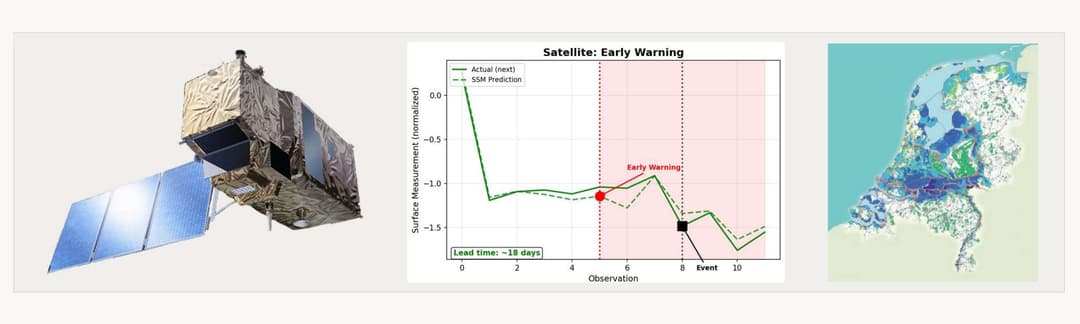
Niva built an early-warning demonstration on the Dutch coast using real Earth observation data, pulling six months of Sentinel-1 SAR and Sentinel-2 optical imagery from Google Earth Engine over a 10km area of interest near Noordwijk (4.5°E, 52.0°N), June through December 2024. The dataset combined 59 SAR observations (VV/VH dual-polarization, roughly three-day revisit) with 13 optical observations across visible and near-infrared bands. Both streams ran through the same Manifold architecture used for robotics sensor streams, with the perception layer adapted to satellite quantities. The result was roughly 18 days of lead time on early-warning divergence in the observation sequence.
The data
- 10km coastal area of interest near Noordwijk, Netherlands.
- 59 Sentinel-1 SAR observations, VV/VH dual-polarization, roughly three-day revisit.
- 13 Sentinel-2 optical observations across visible and near-infrared bands.
- Six-month window, June through December 2024, pulled from Google Earth Engine.
One architecture, two domains
The Manifold architecture that processes robot sensor streams in our manufacturing and robotics work integrated heterogeneous orbital sensor streams without changes to the core. SAR cuts through cloud cover and captures dielectric properties; optical captures surface reflectance and vegetation state. Each stream alone is partial. Integrating them through a deterministic world model is what lets the system flag divergence early, before either stream individually crosses a threshold.
Niva Apogee: physics-native intelligence for space operations
Manifold was first demonstrated publicly on manufacturing process control. The Netherlands work shows the same architecture handling Earth observation data at orbital scale, on real ESA imagery, without retraining or re-architecting. Coastal monitoring, port operations, infrastructure resilience, and climate adaptation rest on the same problem shape: noisy, multi-source, asynchronous orbital observations integrated into a coherent temporal model. The Dutch coast demonstration is one instance of that broader pattern, and one of the use cases Niva Apogee is built to serve.
We didn't design Manifold for flood detection
Manifold wasn't built to predict coastal flooding. It also wasn't built for honey-pour quality gates or grid navigation at city scale. It was built around constitutive physics that runs continuously and a deterministic world model that is indifferent to the specific scenario. Given sensor data, the platform refines its world model with attribution: what is happening and why, what has happened and why, and what will happen and why. The Netherlands demonstration is one instance of that. In fact, most of our demos are. Such is the power and adaptability of a physics-native, deterministic, State Space world model.